LiDAR - Light Detection and Ranging
Elevating The Performance of Ranging and Remote Sensing Systems
- Robust fiber lasers for LIDAR applications
- Widely deployed and proven in demanding LIDAR systems
- Highest performance to enable fast, high resolution, precision mapping
- Short pulses, narrow line widths, high peak powers, high rep rates
An acronym for light detection and ranging, LIDAR is a remote sensing method that uses pulsed laser to measure ranges (variable distances) and generate precise, 3D data. The key component of a quality LIDAR system is the laser source transmitting the beam.
Spectra-Physics’ VGEN-SP LIDAR fiber lasers incorporate state-of-the-art technology for top performance in technically demanding LIDAR and range finding applications. Our unique short-pulse fiber lasers boast high peak power levels and repetition rates, narrow spectral properties, and excellent beam quality, enabling high-altitude mapping with increased resolution, precision, SNR, and scanning time in top-tier airborne or mobile LIDAR systems.
Principles of LiDAR Data Collection
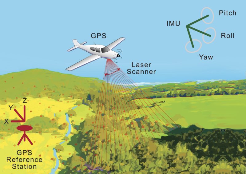
The basic principles of LiDAR are shown in Figure 1. The airborne LiDAR system is comprised of three major time-synchronized components: a laser scanner unit, a GPS, and an IMU. The laser scanner is composed of a laser range finder unit, which is based on time-of-flight distance measurement techniques, and a beam deflection device that creates the desired scanning pattern. The GPS provides the absolute position of the sensor platform (plat), and the IMU records the angular attitude of the platform (including roll, pitch, and yaw/heading).
Please see our LiDAR and LiDAR Mapping application notes for additional information. Application example: